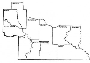
The southwest Arkansas territory of the AAS-SAU Research Station: Calhoun, Columbia, Hemsptead, Howard, Lafayette, Little River, Miller, Nevada, Ouachita, Sevier, & Union Counties.
The Arkansas Archeological Survey’s SAU Research Station staff serve the citizens of eleven counties in southwestern Arkansas (see map). The station territory stretches from the southern edge of the Ouachita Mountains to the Arkansas/Louisiana state line, and incorporates the Great Bend region of the Red River. Much of our current fieldwork, research, and writing focuses on historical archeology in southwestern Arkansas and our continuing work on the archaeology of the Caddo peoples who lived in the area prior to 1835. Southern Arkansas University has hosted this station since 1968, and we curate over 3,100 boxes of artifacts from various sites around southwest Arkansas and neighboring states. Below is just a sampling of our current and past research projects.
Current, Recent, and On-going Projects
- Nakuukuwidish/Holman Springs: This site in western Sevier County is one of a handful of known Caddo saltmaking sites in southwest Arkansas, and one of the largest. Our staff began research there in the 1980s under Frank Schambach, and we restarted research in the mid-2010s under Carol Colaninno. We hosted the 2022, 2023, and 2024 Arkansas Archeological Society training programs at the site, uncovering dozens of features and recovering hundreds of thousands of pottery fragments. Analysis of this massive collection is ongoing.
- Civil War Battlefields: We continue to work on numerous battlefields here in Arkansas, particularly those related to the 1864 Camden Expedition, though we have directed and co-directed numerous projects further afield, particularly research on the March, 1862, Battle of Pea Ridge. Other fields, like Elkins’ Ferry, Prairie D’Ane, Wallace’s Ferry, and more continue to draw our attention.
- Dooley’s Ferry: Dooley’s Ferry was an important crossing on the Red River from the 1820s through the 1930s and was an important feature of the militarized landscape of the Trans‐Mississippi Theater of the Civil War. Archeological excavations here offer a unique opportunity to study the flow of goods and people engaged in local, regional, and global markets into and out of what was a remote corner of the South in a time of great disruption to the patterns of everyday antebellum life. AAS-SAU Research Assistant Dr. Carl Drexler is leading excavations at Dooley’s Ferry and this data was the subject of his dissertation at the College of William and Mary. Carl has conducted fieldwork at the site on and off since 2008—including a couple weeks of work during the 2010 University of Arkansas Archeological Field School.
- Georgia Lake: This small site in Ouachita County was the site of the 1987 Arkansas Archeological Society Training Program. Never written up, we are now working to explore what our predecessors uncovered and to add to our understanding of Caddo heritage in the area.
Important Past Projects
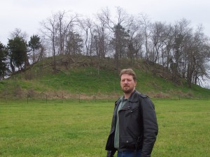
- Crenshaw Mounds (Miller County): One of the largest of the Early Caddo Indian ceremonial centers the Crenshaw site. The archeology of this site may shed light on the original of Caddo culture itself. At the Crenshaw Site, funeral activities included a variety of programs. Some people were buried in mounds, others were buried in large communal graves, and still others underwent extended treatment that led to the specialized burial of skulls and mandibles. Different funeral practices took place at early Caddo mound centers elsewhere in the region, although the skull and mandible burials are unique. These elaborate practices demonstrate that social differences marked special privileges and roles for some members of early Caddo society. Funeral rites are displays of new religious beliefs and rituals that continue as core elements of the Caddo culture. Former AAS-SAU Research Station Archeologist Dr. Frank Schambach (see the “Station History” page) is busy in his retirement writing up the Crenshaw material. Additionally, current University of Arkansas Ph.D. student John Samuelsen has been working at the Crenshaw site using new, high-tech remote sensing techniques.
- Battle Mound (Lafayette County):The Battle Mound site is a premier Middle and Late Caddo (ca. A.D. 1200-1680) mound site located in the Great Bend region of the Red River basin in Lafayette County,
Arkansas. The Battle Mound site (and the surrounding area) is a place that is significant to the Caddo people, removed from this area in the 19th century, and to archeologists, bothof whom are interested in documenting and developing a broader understanding of the occupational history of the Caddo Indians in the Great Bend region. Continuing research by Dr.Duncan P. McKinnon (UCA) is seeking to explore the cultural and natural history at the Battle Mound site. Current investigations include the use of high-tech remote sensing methods to explore the subsurface and identify areas of cultural occupation, archeo-historical investigations that seek to extract and synthesize data associated with historical excavations at and around the site, and geomorphology and flood history research to better understand the relationship of the Battle Mound site to the surrounding dynamic Red River landform processes.
- Ferguson (Hempstead County): The Ferguson site–a small, two-mound site located in the Little Missouri drainage in Southwest Arkansas, is the most completely excavated Late Caddo ceremonial center in Arkansas. Excavations were done at Ferguson in the early 1970s by the Arkansas Archeological Survey with the assistance of the Arkansas Archaeological Society under the direction of Dr. Frank Schambach. The accompanying photographs show some of the extremely well preserved remains of ritually dismantled and burned temples
-
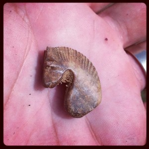
Carved bone chess piece (knight) recovered from an 1830s storefront cellar in Historic Washington State Park
Historic Washington (Hempstead County): The antebellum town of Washington, Arkansas in Hempstead County was once the county seat, the Confederate state capital during the Civil War and a booming cotton town on the Southwest Trail. It is perhaps the best surviving example of a nineteenth century town in the Old Southwest. Unfortunately, the town’s prosperity was short-lived. Several devastating fires and its omission from major railway routes condemned Washington to the role of economic backwater for much of the early twentieth century. Its influence and eventually the county seat (in 1939) was taken by Hope eight miles away on that railroad.
- Royston House: 2007-2009 excavations at the home of Grandison Delany Royston, an important lawyer and law-maker in early Arkansas. Conducted by Dr. Jamie Brandon.
- Abraham Block House: 20010 excavations at the home of an important early Jewish merchant on the frontier. Conducted by David Markus and Dr. Jamie Brandon.
- Block 6, Merchant District: Two Arkansas Archeological Society Summer Training Programs (2011 & 2012) were conducted on this now empty lot that was once (1830-1880) the center of the Washington merchant district. Directed by Dr. Jamie Brandon.
- Van Winkle’s Mill (Benton County): Although Van Winkle’s Mill is not within the station territory of the SAU Research Station, it is (in a sense) a station project as Jamie Brandon, now the SAU Station Archeologist, has directed the Van Winkle’s Mill Archeological Project since its inception in 1997. Nestled in a narrow hollow in the Ozark Mountains of Northwest Arkansas, Van Winkle’s Mill was an important sawmill community in the region from the 1850s until the early 1900s. The mill and community were founded by Peter Van Winkle , an Ozark entrepreneur who rose to the elite circles of Northwest Arkansas society. Interestingly, part of the labor that operated Van Winkle’s Mill was enslaved prior to the war and African-American Freedmen stayed on and worked the mill following emancipation. This makes Van Winkle’s Mill a great site to address the often forgotten industrial and African-American heritages in the Ozark region.
- Cedar Grove (Lafayette County):The Cedar Grove site was located in Lafayette County on the banks of the Red River. The site, consisting of both a late Caddo farmstead (with an accompanying cemetery) and an early twentieth century African-American cemetery, was discovered during construction of the Field Revetment by the New Orleans District of the Corps of Engineers. As the site was slated for destruction, both components had to be moved. Excavations were conducted intermittently between June of 1980 and June of 1982 by a comprehensive interdisciplinary team that recovered data on the historic remains, settlement systems, lithics, ceramics, geomorphology, chronology, floral and faunal remains, pigments and bioarchaeology.
- Gateway Texarkana (Miller County): Dr. Beverly Rowe, along with her students at Texarkana College, has teamed up with the Texas Archeological Society, the Arkansas Archeological Society and the AAS-SAU Research Station to conduct a 4-year project excavating sites in downtown Texarkana with AAS-SAU Research Associate David Jeane serving as Field Director.
- Grandview Prairie (Hempstead County): The area known as Grandview Prairie is located in Hempstead County near Hope, Arkansas, in the southwestern part of the state. This 4885-acre property, originally the antebellum Grandview Plantation, is now the Grandview Prairie Wildlife Management Area, owned by the state of Arkansas and managed by the Arkansas Game and Fish Commission. The property had been protected from development and from looters by its previous owners. As a consequence, numerous historic and prehistoric archeological sites within the boundaries of Grandview Ranch remain largely undisturbed and many are in pristine condition.
- Sulfur Fork Factory (Miller County): In 1795 the United States government began operating a system of posts, called factories, for regulating trade with Native American groups. As whites began settling in Louisiana and developing commercial relations with Native Americans, a factory was established at Nachitoches to oversee trade and to administer Indian affairs in general. Problems over the location of the factory buildings as well as conflicts with the local merchants made it advisable to move the factory farther up the Red River. The location recommended was on a high bluff on the west bank of the Red River near the mouth of the Sulphur Fork.


