The Arkansas Archeological Survey does a very small amount of geophysical survey in cemeteries. This is usually when the site is under threat or certain conditions are met (see our “Guidelines for Cemetery Preservation Support” on our Cemetery Preservation page for more information). Such survey can (but do not always) identify unmarked graves below the surface.
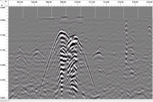
Under the best conditions, we get something like… this!
This is a slice of data from a ground-penetrating radar. Imagine that the top of the slice is the ground surface, and the instrument ran along it, collecting data below, moving left to right. The slice shows the things underneath the ground as if you were standing underground looking right at them. In this case, the hard black-white parabolas in the center of the plot are two intact caskets situated right next to each other. Because of the way the radar waves travel, the tops of the caskets are at the tops of the parabolas, and the banded areas underneath do not mean that the caskets are that tall, but that they are blocking the signal.
That’s what they look like ideally. Often, it’s a lot harder to pick them out, so we look for patterns in the data that suggest graves are present. This means consistent lines of data blips, generally oriented east-west (for Christian graves).
The data shown here are from the Ebenezer Cemetery, in Nevada County. It’s a project that we collected the data on in 2015, but for a host of reasons, are just getting processed now.

